|
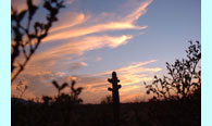
Short Takes
Our Sincere Thanks
The Arizona Wilderness Coalition would like to sincerely thank the following volunteers and wilderness advocates for their dedication and energy on a variety of wilderness service projects throughout Arizona. We’re always looking for more hardy souls!
 Craig Weaver, at Saddle Mountain, and Harquahala and Hummingbird Mountains Craig Weaver, at Saddle Mountain, and Harquahala and Hummingbird Mountains
Judy Shaw, at Saddle Mountain and the Palo Verde Hills
Jim Scarantino, at Gila National Forest
Tom and Tomas Taylor, at Martinez Canyon
Guenille Rubin, at Grief Hill Roadless Area, Prescott National Forest
Ellen Petersen, at the Black Canyon Roadless Area, Prescott National Forest
Tom Holtz, in the Crossman Peak Proposed Wilderness area
Doug Newton, in the Buckskin Mountains Proposed Wilderness area
Prescott College Wilderness Orientation, at the Chevlon Canyon Roadless Area and on Wild and Scenic River Segments
Prescott College Adventure Education Classes, at Agua Fria National Monument and the Sheridan Mountain Roadless Area, Prescott national Forest
Doug Hulmes, at the Ash Creek Roadless Area, Prescott National Forest
Patty Stern, at Gila National Forest
Prescott College Geographic Information Science Class, at Hassayampa River Canyon Wilderness and Round Mountain additions
Liz Boussard, at Grand Canyon-Parashant, Vermillion Cliffs, and Kaibab National Forest
Donna Cassano, at Vermilion Cliffs and Kaibab National Forest
Lou Arminio, at Vermilion Cliffs and Sand Tanks
Zachary Huntington, at Grand Canyon-Parashant
Alison French Steen, at Hurricane Cliffs
Oscar Simpson, at Gila National Forest
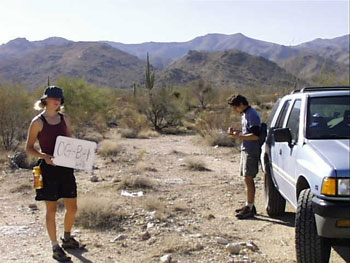
Road Rules, Sky Island Style
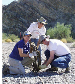
Volunteers in the Gila National Forest
weld a road barrier that is now passable
only by foot and horse travel.
From left, Jim Scarantino,
Oscar Simpson, and Patty Stern.
While the national debate of protecting roadless areas continues to boil in Washington, the Sky Island Alliance and cooperating organizations continue to make positive steps towards protecting and expanding roadless areas in Arizona. In October, Sky Island Alliance, Upper Gila Watershed Alliance, New Mexico Wilderness Alliance, and Republicans for Environmental Protection held the first-ever volunteer road closure event in the Gila National Forest.
Twenty-five volunteers from Tucson, Silver City, Albuquerque, and elsewhere traveled to the Big Burro Mountains west of Silver City and put three roadbeds to rest. Using welders, shovels, picks, pipe, and lots of determination, volunteers put their back into it. In two days, we successfully closed 2.4 miles of roads that intruded into a previously designated roadless area near Wildhorse Canyon. Events such as this show that local citizens can make a difference, and while we continue to advocate for strong national wilderness policy in Washington, real differences are often made at home. A hearty thanks goes out to all the volunteers that made the Gila closures possible!
Click here to contact your AWC Regional Coordinator for more opportunities like these in your neck of the woods.
Join Our Wilderness Teams!
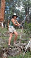
Wilderness Suitability Inventories
The Arizona Wilderness Coalition is coordinating fieldwork inventories and reviewing areas suitable for wilderness designation across Arizona. We are looking for volunteers to help evaluate both National Forest Service and Bureau of Land Management lands. These inventories seek to identify and characterize through detailed field observations and photographs:
- areas where significant intrusions—such as roads or manmade structures—have occurred since potential wilderness boundaries were originally drawn, possibly making such areas unsuitable for wilderness;
- areas requiring ecological restoration;
- areas possessing wilderness qualities that were overlooked in earlier fieldwork and should now be added to an updated proposal; and
- to update the inventory information about suitable areas that did not get legislatively designated in Arizona’s previous wilderness bills.
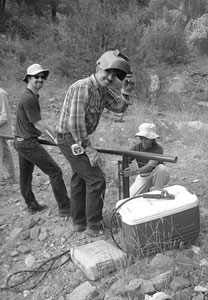
Inventories often involve careful recording of existing structures,
roads, trails, and other manmade features.
Inventory data will be used to ensure that all units are protected from intrusions such as roads or lasting structures, and that there is solid justification for including a given intrusion in the wilderness boundary. The ultimate goal is to guarantee that all inventoried areas qualify for wilderness designation and are included in a legislative wilderness proposal for Arizona. Contact your nearest AWC regional coordinator for more details. Read more...
Adopt-A-Wilderness
 Every wilderness and roadless area needs a protector and an advocate--someone who is willing to get to know the land. If you have a favorite roadless area, or if you would like to find a new favorite roadless area, think about adopting! The Arizona Wilderness Coalition will gladly help you choose an area and will provide you with all of the necessary information and skills needed to inventory and protect your adopted area. Every wilderness and roadless area needs a protector and an advocate--someone who is willing to get to know the land. If you have a favorite roadless area, or if you would like to find a new favorite roadless area, think about adopting! The Arizona Wilderness Coalition will gladly help you choose an area and will provide you with all of the necessary information and skills needed to inventory and protect your adopted area.
Through the adopt-a-wilderness effort, the Arizona Wilderness Coalition is looking for volunteers to adopt wilderness and potential wilderness areas. Adopters will serve as wilderness stewards by exploring self-selected areas and reporting any adverse activities. They can also help out with the wilderness suitability evaluations on adjacent or nearby roadless areas. Contact your nearest AWC regional coordinator for more details. Read more...
Roadless Rule Reigns
In January of 1998, Forest Chief Michael Dombeck proposed a moratorium on road building within most of the remaining roadless areas on National Forest Lands. Until that time, it had been since 1978 when the Forest Service dealt with the management of roadless areas from a national perspective.
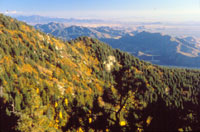
Photo: Matt Scroch
Realizing the economic, ecological, and social benefits of preserving remaining wildlands, President Clinton then, in October of 1999, directed the Forest Service to undergo a rulemaking process that would protect these lands. The American public responded with overwhelming support – sending in 2 million comments urging the administration to protect roadless areas (95% of the comments were in favor of strong roadless area protection). This momentum resulted in a final national rule, released on January 5, 2001, that would protect 58.5 million acres from road building, commercial logging, and other extractive activities. It was a monumental achievement for conservationists and wildlands around the country. Exceptions were made that allowed motorized access for public safety, timber thinning, and various grandfathered activities.
It took one of America’s largest timber companies, Boise Cascade, only three days to file a lawsuit against the government to halt the rule. The States of Idaho, Alaska, North Dakota, Montana, Colorado, and Wyoming all followed suit, either bringing lawsuits of their own, or supporting lawsuits of neighboring states. Unfortunately, by then the Bush Administration was taking control of office, and refused to defend the Roadless Rule at the first hearings in Idaho. With no defense, the Idaho Judge eventually issues a preliminary injunction of rule and agrees with plaintiffs that the rule was adopted illegally.
Today, the fate of the original Roadless Rule stands in various courts around the country. In August of 2002, the U.S. Justice Department unexpectedly issued an eighty-page brief to a North Dakota court vigorously defending the Roadless Rule. Conservationists were positively surprised at the administration’s decision to now, after bluffing on the rule, turn around and defend it. On December 12, the 9th Circuit Court ruled on an appeal of the Idaho case. In a historic decision, the 9th lifted a preliminary injunction, making the Roadless Conservation Rule the law of the land! The case will return to the Idaho Court for final ruling. For the first time since its inception, the Roadless Rule is now protecting roadless areas around the country. Coming months will bring more news on this important conservation issue – we’ll keep you posted!
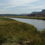
The Fate of the Colorado: YOU Decide!
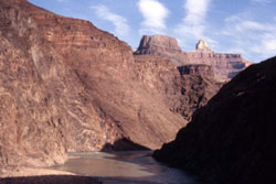 The National Park Service is currently revising its Colorado River Management Plan (CRMP) for the Colorado River as it flows through Grand Canyon National Park. Citizens must help the Park Service address two critical issues — wilderness protection and non-commercial access — to better protect the river’s natural character. Read more... The National Park Service is currently revising its Colorado River Management Plan (CRMP) for the Colorado River as it flows through Grand Canyon National Park. Citizens must help the Park Service address two critical issues — wilderness protection and non-commercial access — to better protect the river’s natural character. Read more...
Photo: Kim Crumbo
The Park Service will commence a series of meetings this spring to begin gathering public feedback on management of the river. The meetings will involve stakeholder workshops and expert panels. The stakeholder workshops will cover the noncommercial (self-guided) trip permit system, and the spectrum of river running concession services to be provided to the public. The expert panel sessions will cover the physical, social, and ecological carrying capacity of the river, group size and recreational allocation and distribution.
The first expert panel will be held on Wednesday, January 29, from 2 to 5 p.m., and 6 to 9 p.m. The second expert panel will be held on Friday, January 31, from 8 to 11 a.m., and 1 to 4 p.m. The two stakeholder workshops will be held Thursday, January 30, at times to be announced. The sessions will be videotaped and made available to interested persons not able to attend the Arizona meetings.
All expert panels and stakeholder workshops will be held at the Arizona State Capitol building in the Governor's Protocol Room, 1700 West Washington, in downtown Phoenix, and video-conferenced to a room—as yet unspecified—at Northern Arizona University in Flagstaff.
All events will be open to the public and the expert panels will allow for questions by the audience.
For further information contact Kim Crumbo at kcrumbo@grand-canyon.az.us, or at (928) 638-2304.
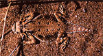
Doom for Desert Lizard?
 The Fish and Wildlife Service (FWS) has recently withdrawn a 1993 plan to list the flat-tailed horned lizard as threatened, saying "the science did not indicate that the species required the listing." The Fish and Wildlife Service (FWS) has recently withdrawn a 1993 plan to list the flat-tailed horned lizard as threatened, saying "the science did not indicate that the species required the listing."
Found in desert dunes in California, Arizona, and northern Mexico, the lizard is declining largely because of habitat destruction—including farming, housing, off-road vehicle use, geothermal leases, and military exercises.
Other factors responsible for the decline of this species include the use of pesticides on crops. Pesticide drift is thought to affect ant populations in adjacent habitat. Flat-tailed horned lizards feed primarily on native harvester ants, consuming 150-200 ants per day.
 This Sonoran Desert native resembles a mini-dinosaur and typically measures approximately 3.3 inches from snout to vent. Markings include two rows of fringed scales on either side of the body with a dark stripe along its backbone. This Sonoran Desert native resembles a mini-dinosaur and typically measures approximately 3.3 inches from snout to vent. Markings include two rows of fringed scales on either side of the body with a dark stripe along its backbone.
Although the government first proposed protection for the lizard under the Endangered Species Act in 1993, it withdrew its proposal in 1997 citing inadequate data. FWS proposed listing the lizard again in 2001, citing studies that showed 49 percent of the lizard's habitat was damaged, lost, or fragmented, but the agency has again withdrawn the rule, saying that a listing is “no longer warranted,” according to FWS spokesperson Jane Hendron.
Photos courtesy of Wendy Hodges, Center for Conservation Biology, University of California-Riverside
--courtesy of the Center for Biological Diversity
|
|
|

 Make your late winter and early spring outdoor plans here! Visit our comprehensive list of day outings, inventory trips, meetings, and upcoming AWC events for the latest in wilderness “happenings” around the state.