|
|
RESOURCES
Resources: Annual Reports | Newsletters | Fact Sheets | Reports & Proposals | Links | Press Releases
Vermilion Cliffs National Monument
 Wilderness
Protection Wilderness
Protection
Wilderness
affords the highest level of protection for the variety of ecological
and archeological treasures of the Vermilion Cliffs National Monument,
one of Arizonas newest public lands. The Arizona Wilderness Coalition
proposes six wilderness additionsapproximately 169,000 acresto the Monuments
existing Paria Canyon-Vermilion Cliffs Wilderness Area. The proposed wilderness
excludes approximately 120 miles of the Monuments road corridors, which
will retain for visitors ample mechanized access to the Monuments interior
and many scenic overlooks.
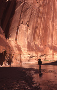
Crimson
2,000-foot escarpments guard the majestic Paria Plateau, the heart of
the Vermilion Cliffs National Monument. Above the cliffs, rolling sand
dunes, grass-lands and woodlands, and colorful sandstone buttes guild
the expan-sive Plateau. The Paria River Canyonrenown for its grandeur,
inviting grottos, and challenging hikesdivides the monument into isolated
regions. Buckskin Gulch, a 12-mile long stone incision, provides a stimulating,
intro-spective path to the Plateau's innermost realm.
The
Paria River drains the Paria Plateau, the heart of the 290,000-acre Vermilion
Cliffs National Monument. The Plateau is one of the lower large steps
in the Grand Staircase, consisting of brilliant, relatively uniform
Triassic and Jurassic rock layers such as the Chocolate Cliffs of Moenkopi
sandstone, Chinle shale, red Moenave and Kayenta formations, and the massive,
wind-deposited Navajo sandstone.
Species Diversity
Pinyon/juniper
woodland, shrub lands, and limited upland grasslands dominate the Paria
Plateau, also referred to as the Sand Hills. The Bureau of Land Management
considers portions of the Monument as important habitat for the North
Kaibab deer herd, which may seek lower elevation pastures in House Rock
Valley during winter. The agency has worked with the Arizona Game and
Fish Department to restore desert bighorn sheep to the Paria drainage.
These releases have successfully restored bighorn sheep into the lower
Paria and upper Grand Canyon areas.
Recent
efforts to reintroduce the endangered California condors appear successfulthe
magnificent birds now roost and nest in the Vermilion cliffs. The threatened
Brady pincushion cactus occurs around the base of the Paria Plateau. This
unique and tiny cactus spends most of the year just beneath the soil surface.
During spring rains, the plant swells and partially emerges, then blooms
at night with showy white flowers. As late spring drought develops, the
cactus shrinks back underground, remaining hidden until the next spring.
Gray
wolves, a critical keystone species in many ecosystems, once inhabited
the Southwest, including the Paria Plateau. Unfortunately, the last known
gray wolf of the Grand Canyon region fled across the Plateau trying to
escape from pursuers, and reintroduction efforts in the Southwest have
been unsuccessful for a variety of political reasons.
Cultural Significance
In
the 12 th century, Virgin Branch Pueblo II and IIIalso referred to as
the Anasazi peopleoccupied the Paria Plateau and its surrounding vicinity.
A relatively high density of archeological sites, including 30- to 50-room
pueblos, lie scattered across Paria Plateau. Although groundwater on the
Plateau is scarce, these ancient people used rainwater from natural catchments
and small, constructed reservoirs.
The
Monument has a rich history of exploration and settlement that spans more
than two centuries. In 1776, the Dominguez-Escalante Expedition descended
into House Rock Valley and camped near Jacobs Pools at the base of the
Vermilion Cliffs. They proceeded on to the mouth of the Paria River and
spent a week trying to ford the Colorado River near Lees Ferry. Jacob
Hamblins 1858 expedition was the first of thirteen visits to the Hopi
Nation. Hamblin recognized the need for a ferry at the mouth of the Paria
River, and in 1864, was the first to successfully cross the Colorado River.
In 1871, the notorious John D. Lee established what would come to be known
as Lees Ferry. The region also boasts a rich cowboy history and currently
offers opportunities for ranching, hunting, fishing, river running, and
ecotourism.
Threats
Potsherd
hunting has done considerable damage to the Paria Plateaus archeological
resources. In one of the few cases to be investigated, a potsherd hunter
excavated and looted 34 pits and trenches in two large prehistoric sites.
Off-road
vehicles continue to pose a considerable threat to the Monuments wildlife,
archaeology, vegetation, and tranquility. A network of primitive roads
beckons off-road enthusiasts and continues to impact the areas cultural
and natural resources. Existing paved, fenced highways may block wildlife
movement, particularly pronghorn antelope.
Water
development has altered or destroyed the ecological integrity of springs
and ecosystems along the east and southeast flanks of the Paria Plateau.
Livestock grazing, trampling, and trailing degrade vegetationincluding
the threatened Brady pincushion cactussoils, and site stability.
|